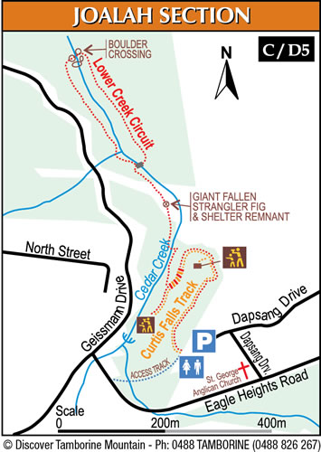
Joalah Section
Tamborine Mountain is a nature lover’s paradise. The famous “Witches Falls” section of the Tamborine National Park was declared in 1908, making it Queensland’s first national park. Over the years additional reserves have been declared and today the park is made up of 13 sections of land on the Tamborine plateau and surrounding foothills. There are a large number of beautiful rainforest bushwalks, most tracks are under 3 kms taking about 1 hour, are well established, and easy to follow.
Access:
For ease of parking, turn off Eagle Heights Road into Dapsang Drive at the “St George Anglican Church”, there is a very large parking area to the left at the end of the street. This parking area serves the church as well as the walking trail.
“Dapsang Drive” Carpark:
Car parking spaces: 42
Disabled car parking spaces: 2
Bus parking spaces: YES – 3
Public Toilets: YES
BBQs: NO
Picnic Settings: NO
Sheltered Picnic Settings: NO
Additional seating: NO
Views: NO
Information Board: YES – General Information
Alternatively, you can also access the start of this walk via a 400meter long walk starting via a small timber bridge at the “Curtis Corner” T- junction of Eagle Heights Road and Geissmann Drive. This is a popular tourist stop with several cafes and eateries, so parking is limited at times.
“Curtis Corner” T-junction:
Car parking spaces: 20
Disabled car parking spaces: 1
Public Toilets: NO – but available in food outlets
BBQs: NO
Picnic Settings: NO
Sheltered Picnic Settings: NO
Additional seating: NO
Views: NO
Information Board: YES – General Information

Curtis Falls (D5) 1.5km return, 101 steps, moderate grade with some steeper sections, allow 60 minutes return with plenty of time to admire the waterfall.
The start of the track meanders downhill through wet eucalypt forest beneath towering flooded gums.
Take advantage of the viewing platform on the left, allowing rainforest views towards the creek below. A plaque gives information about the illusive “Albert’s Lyrebird”. Joalah is an Aboriginal word meaning “Haunt of the Lyrebird”. During the winter months, the loud calls of the male Albert’s Lyrebird can still be heard (12 stairs).
After the viewing platform the track gradually descends to Curtis Creek, which is reached after the last set of steps.
You will notice a drop in temperature as you descend into lush rainforest. Look out for beautiful crows nests and staghorn ferns growing in the canopy above (106 stairs).
Turn left to reach beautiful Curtis Falls, only a short stroll away. The falls run all year-round, however, they are at their most spectacular after heavy rainfalls. The track ends at a viewing platform overlooking a large rock pool, with great views of the falls and the surrounding columnar basalt rock face (6 stairs).
Please note that swimming is prohibited at the falls, there is a restricted access area below Curtis Falls protecting a fragile glow-worm colony. The large tree trunk slowly descending into the rock pool is tempting to explore, but please resist entering the area outside the viewing platform fence, and observe the following warning sign:
REGULATORY NOTICE:
Restricted Access Area
Public Safety and Conservation
The rockpool and surrounding area beyond the viewing platform have been declared a restricted access area. This is for the safety of visitors and protection of glow worms and platypus population.
Visitors must remain on the viewing platform. Entry to the restricted area is prohibited without a permit or written approval. Contravention of the requirements of this notice is an offence under the “Nature Conservation Act 1992”. Maximum penalty 80 penalty units and on the spot fines of up to $6000.
There is also another sign:
For further information call 1300 130 372 or contact:
Ranger in Charge, Tamborine National Park, Knoll Road, North Tamborine Qld 4272, ph (07) 5545 1171
Help conserve the Glow Worms!
You can help conserve the glow worms in other ways:
– don’t smoke or use aerosol sprays or insect repellents near this site
– do not shine torches at the glow worms or the cliff face
– do not use camera flashes or bright lights
Joalah Lower Creek Circuit (D5 / C5):2.4 km return, allow about 1 hour, easy grade
Instead of heading back up to the car parking area again coming back from Curtis Falls, you can follow the piccabeen palm-fringed “Curtis Creek” which starts at the “T” junction, passing several smaller cascades. Start the circuit walking left crossing Curtis Creek via a concrete bridge, offering beautiful views of the creek in both directions. The rainforest trees are laden with elk horns, stag horns and birds nest ferns. The track passes a large clearing which was created by a fallen giant strangler fig (20 stairs).
There are also remnants of a hut, evident by a weathered concrete slab and the remains of a bush rock retainer wall. The short track to the left is closed; it leads back to Geissmann Drive / Tamborine Mountain Road.
A bit further down the track, another concrete bridge leads again across the creek, this path should be chosen if walking with children or basic footwear. The normal track continues on the left creek bank, winding up and down, with some very narrow sections. Sometimes, street noise can be heard (42 stairs).
Eventually, an easy “hop-over boulder” crosses the creek at the bottom-most point of the walk (46 stairs).
After the boulder creek crossing, the track turns right back towards Curtis Falls. The track to the left is closed and becomes impassible after a short while, as it is no longer used. Please keep out, the track is no longer safe to use, with rockslides and slippery surfaces.
The track passes several very nice rock pools, which are easily accessible, inviting the walker to stop and admire this wonderful National Park. A couple of sections are slightly rougher, please take care when navigating. Eventually, the track crosses the concrete bridge mentioned earlier (18 stairs).


